The RANGER Navigator
Carnegie Mellon researchers are developing a software
control system for cross country autonomous vehicles called RANGER, for
Real-time Autonomous Navigator with a Geometric Engine. The goal of the
project is to increase speed and enhance the reliability of robotic
vehicles in rugged outdoor settings.
RANGER has navigated over distances of 15 autonomous
kilometers, moving continuously, and has at times reached speeds of 15
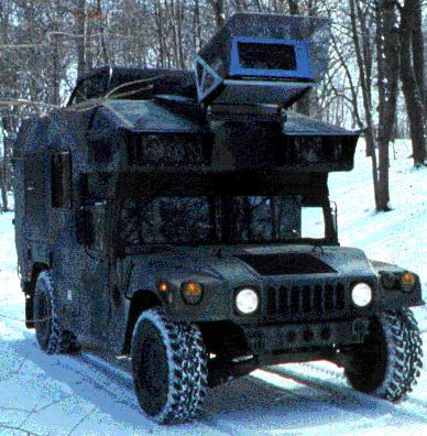
km/hr. The system has been used successfully on a converted U.S. Army
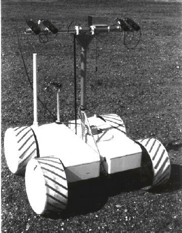
jeep called the NAVLAB II and on a specialized Lunar Rover vehicle that
may, one day, explore the moon.


The key to the success of the system is its
adaptability. It explicitly computes the vehicle reaction time and
required sensory throughput and adapts its perception and planning
systems to meet the demands of the moment.
Operational Modes
The system can autonomously seek a predefined goal or
it can be configured to supervise remote or in-situ human drivers and
keep them out of trouble.
Goal-Seeking
The system can follow a predefined path while avoiding
any dangerous hazards along the way or it can seek a sequence of
positions or a particular compass heading. In survival mode, seeking no
particular goal, it will follow the natural contours of the surrounding
terrain.
World Model
A computerized terrain map data structure is
maintained which models the geometry of the environment. It is an array
of elevations that represents the world as a 2-1/2 D surface where the
vertical direction is aligned with the gravity vector. This
representation, combined with a model of vehicle geometry, permits a
robust assessment of vehicle safety.

Vehicle Model
RANGER is an innovative solution to the difficulties
of autonomous control of land vehicles based on a tightly-coupled,
adaptive feedforward control loop. The system incorporates measurements
of both the state of the vehicle and the state of the environment and
maintains high fidelity models of both that are updated at very high
rates.
At sufficiently high speeds, it becomes necessary to
explicitly account for the difference between the ideal response of the
vehicle to its commands and its actual response. RANGER models the
vehicle as a dynamic system in the sense of modern control theory. The
linear system model is expressed in the following generic block
diagram.

FIFO queues and time tags are used to model the delays
associated with physical i/o and to register contemporary events in
time. The command vector u includes the steering, brake, and throttle
commands. The disturbances ud model the terrain contact constraint. The
state vector x includes the 3D position and 3 axis orientation of the
vehicle body as well as its linear and angular velocity. The system
dynamics matrix A propagates the state of the vehicle forward in time.
The output vector y is a time continuous expression of predicted
hazards where each element of the vector is a different hazard.
Hazard Assessment
Hazards include regions of unknown terrain, hills that
would cause a tip-over, holes and cliffs that would cause a fall, and
small obstacles that would collide with the vehicle wheels or body.
The process of predicting hazardous conditions
involves the numerical solution of the equations of motion while
enforcing the constraint that the vehicle remain in contact with the
terrain. This process is a feedforward process where the current
vehicle state furnishes the initial conditions for numerical
integration. The feedforward approach to hazard assessment imparts
high-speed stability to both goal-seeking and hazard avoidance
behaviors.
System components above the state space model in the
software hierarchy translate the hazard signals y(t) into a vote
vector. This is accomplished by integrating out the time dimension to
generate a vote for each steering direction based on a normalization of
the worst case of all of the considered hazards.


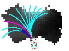
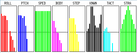
In the figure, the system issues a left turn command
to avoid the hill to its right. The histograms represent the votes for
each candidate trajectory, for each hazard. Higher values indicate
safer trajectories. The hazards are excessive roll, excessive pitch,
collision with the undercarriage, and collision with the wheels. The
tactical vote is the overall vote of hazard avoidance. It wants to turn
left. The strategic vote is the goal-seeking vote. Here it votes for
straight ahead.
Arbitration
At times, goal-seeking may cause collision with
obstacles because, for example, the goal may be behind an obstacle. The
system incorporates an arbiter which permits obstacle avoidance and
goal-seeking to coexist and to simultaneously influence the behavior of
the host vehicle. The arbiter can also integrate the commands of a
human driver with the autonomous system.
Sensors
RANGER accommodates both laser rangefinder and stereo
perception systems and it incorporates its own integrated stereo
correlation algorithm. In either case, the design achieves significant
increases in vehicle speeds without sacrificing either safety or
robustness.
Adaptive Perception
Perception has long been acknowledged as the
bottleneck in autonomous vehicle research. Yet, a moving vehicle
generates images which contain much redundant information. Removal of
this redundancy is the key to fast moving robot vehicles.
A new range image perception algorithm has been
developed for RANGER. It selectively extracts a very small portion of
each range image in order to reduce the perceptual throughput to a bare
minimum. In this way, vehicle speed is less limited by the computer
speed.
The algorithm searches each image for a band of
geometry that is between two range extremes, called the range window as
shown in the figure below of a range image of a hill in front of the
vehicle. Only the data between the white lines is processed by RANGER.
The algorithm also accounts for vehicle speed by moving the range
window out as speeds increase.

The approach also stabilizes the sensor in software
because the search for the data of interest adapts automatically to
both the shape of the terrain and the attitude of the vehicle. It is up
to 6000 times faster than traditional approaches and it achieves the
throughput necessary for 20 m.p.h. motion on an ordinary computer
workstation.
Position Estimation
RANGER incorporates a sophisticated Kalman Filter
algorithm that merges the indications of all of the navigation sensors
into a single consistent estimate of the vehicle position, attitude,
and velocity. Any number of sensors in any combination can be
accommodated including, wheel or transmission encoders, compasses,
gyroscopes, accelerometers, doppler radar, inclinometers, terrain aids
such as landmarks and beacons, and inertial and satellite navigation
systems.
Implementation
While the real-time core of the system can be
expressed in about 1000 lines of C, RANGER includes a complete
simulation and development environment incorporating a data logger and
simulators for natural terrain, vehicles, sensors, and pan/tilt
mechanisms. Real-time animated graphics provide feedback to the human
supervisor. A custom C language interpreter is used to configure and
control the system at run-time.
Architecture
Implemented in C language, the system is composed at
the highest level of four objects. The Map Manager integrates all
environmental sensor images into a single consistent world model. The
Controller implements hazard detection and avoidance, goal-seeking, and
arbitrates between them. The Vehicle encapsulates the state of the
vehicle and provides dynamics simulation and feedforward. The Kalman
Filter implements the position estimation system.
Last Modified: 12:16pm EST, November 19, 1996
 Back to Robotics Institute Homepage


 Back to Robotics Institute Homepage