 An overhead view of samples of these patterns
is shown here, as generated by a simulator. The red line shows the path of
the robot itself, while the green shading indicates the extent of coverage
by the sensors mounted on the robot.
An overhead view of samples of these patterns
is shown here, as generated by a simulator. The red line shows the path of
the robot itself, while the green shading indicates the extent of coverage
by the sensors mounted on the robot.Ph.D. Thesis
I defended my thesis on October 2nd, 2000. The abstract is below, and a pdf version of the thesis document is here. A PowerPoint version of my presentation is here.
Abstract:
This thesis introduces the application of solar position and shadowing
information to robotic exploration. Power is a critical resource for robots
with remote, long-term missions, so this research focuses on the power
generation capabilities of robotic explorers during navigational tasks, in
addition to power consumption. Solar power is primarily considered, with
the possibility of wind power also contemplated. Information about the
environment, including the solar ephemeris, terrain features, time of day,
and surface location, is incorporated into a planning structure, allowing
robots to accurately predict shadowing and thus potential costs and gains
during navigational tasks. By evaluating its potential to generate and
expend power, a robot can extend its lifetime and accomplishments. The
primary tasks studied are coverage patterns, with a variety of plans
developed for this research. The use of sun, terrain and temporal
information also enables new capabilities of identifying and following
sun-synchronous and sun-seeking paths.
Digital elevation maps are combined with an ephemeris algorithm to calculate the altitude and azimuth of the sun from surface locations, and to identify and map shadows. Solar navigation path simulators use this information to perform searches through two-dimensional space, while considering temporal changes. Step by step simulations of coverage patterns also incorporate time in addition to location. Evaluations of solar and wind power generation, power consumption, area coverage, area overlap, and time are generated for sets of coverage patterns, with on-board environmental information linked to the simulations. This research is implemented on the Nomad robot for the Robotic Antarctic Meteorite Search. Simulators have been developed for coverage pattern tests, as well as for sun-synchronous and sun-seeking path searches. Results of field work and simulations are reported and analyzed, with demonstrated improvements in efficiency, productivity and lifetime of robotic explorers, along with new solar navigation abilities.
Thesis Proposal
My thesis proposal was presented on December 2nd, 1998. The abstract is below, and a postscript version of the proposal document is here. A postscript version of my presentation notes is here.
Abstract:
A primary goal of surface exploring robots is complete coverage of an area,
so coverage patterns are a major task to be evaluated. The effects of each
task on power and other resources, as well as on the fulfillment of the
robot's goals, need to be evaluated and then weighted by the priorities of
the resources and goals. The priorities are dynamically changing, depending
on the current resource availability and on the goals to be accomplished in
the robot's current mission stage. The weighted evaluations are combined
into one equation, producing a rank for that task. The task to perform can
be chosen based on the rankings of all available task options.
Robotic explorers of remote locations require autonomous capabilities to
select the best tasks to perform. Successfully accomplishing their mission
requires careful utilization of resources, particularly power. The robot
must evaluate each potential task in terms of the power that will be gained
from solar panels or other sources, as well as the power that will be
expended by the performance of the task. The uncertainty of the evaluation
helps determine the level of risk associated with the task. Major parameters
to be considered are the terrain, orbital parameters of the sun, and the
locomotion and power generation capabilities of the robot.
CMU Research
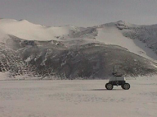
The Robotic Antarctic Meteorite Search combines the efforts of many researchers. The robot we are using as a platform for our work is called Nomad. Nomad was designed and built here at CMU, and was tested in the Atacama Desert in Chile in the summer of 1997. Nomad was prepared for the cold weather in Antarctica, where it was tested in November of 1998.
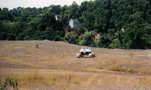
My work is part of the autonomy group's research. I am developing two primary software modules for Nomad. The navigation planner is a module for generating various path plans for Nomad to follow. Currently, this module can generate 3 types of paths: a basically straight line path from one point to another, a straight rows path which covers an area in a back and forth pattern, and a spiral path which covers an area with an expanding spiral-like pattern. This module has been tested in simulation, in Pittsburgh, and in Antarctica. Images of these 3 tests are below.
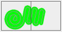
 An overhead view of samples of these patterns
is shown here, as generated by a simulator. The red line shows the path of
the robot itself, while the green shading indicates the extent of coverage
by the sensors mounted on the robot.

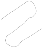
 Actual Differential GPS groundtracks of Nomad following the straight rows and
spiral patterns are shown here, from testing at the slag heaps in Pittsburgh.
The images shown here are the best patterns generated to date. Click on the
images to see a time series of tests that gradually improved the robot's
ability to follow the given patterns.

 Differential GPS groundtrack of Nomad following the straight rows pattern is
shown here, from testing at Patriot Hills in Antarctica. This image shows
a pattern which was interrupted for a side trip investigation, and then
resumed. Click on the image to see other trial runs which were performed.

The second primary software module is the mission planner. This module has not been fully developed yet, and will not be tested this season. The purpose of this module is to evaluate various plans and decide which one the robot should utilize. These plans can include the coverage patterns generated by the navigation planner as well as side trips to investigate objects more closely with various sensors, such as examining a potential meteorite with a spectrometer. The mission planner will take cost estimates from the navigation planner and a sensor manager, and evaluate the costs and benefits of various plans and combinations of plans, picking the best one, based on the goals and constraints of the current mission. Some of these goals and constraints might be complete coverage of an area, certainty of meteorite detection, generation of solar power, and conservation of power needed for locomotion.
Previous Robotics Research
I worked on the AERCam project in the summer of 1997, at Johnson Space Center. AERCam, or Autonomous Extravehicular Robotic Camera, is a small spherical robot designed to fly around the Space Shuttle or Space Station to inspect the outer surfaces, take images from a unique perspective, and aid astronauts during EVA's by providing an additional light source or camera angle. I continued to work on this project and related three-dimensional path planning problems at CMU from fall 1997 through winter 1998.
I worked on a Lunar Optical Interferometer Telescope project at CMU from May - December 1996. This project (which has since been cancelled) dealt with using robots to autonomously deploy multiple telescopes on the surface of the moon, aligning them precisely enough for interferometry. Initial work involved developing a laser pointing system to aid in this alignment.