Learn about our research
Needs Assessment
Towards a realistic understanding of the needs and requirements for developing a navigation solution for the visually impaired, we are conducting detailed needs assessment with our community partners at a few stages of this project.
Process
- Worked with community partners to identify users who could potentially benefit from NavPal.
- Surveyed 20 individuals who are blind, have limited vision, or work with blind and deafblind in 2011. Used a combination of phone and online surveys. Focused survey on specific navigation needs and preferences, NavPal features, customizable options, and the level and frequency of instructions.
Key Findings
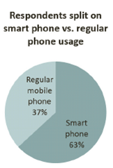
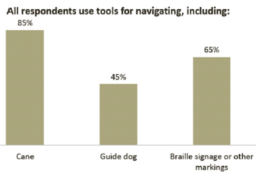
An analysis of the needs assessment results revealed a variety of needs and preferences, including those for audio feedback features, simple menu structures, and customizability of the input/output options and the level and frequency of instructions.
 |
 |
Technical Features
NavPal addresses three key questions essential for robust indoor navigation:
1. Effective localization (Where am I?)
We augment GPS-based solutions with on-board sensing including accelerometer, compass, wireless and GSM (mobile phone signals).

- The first stage of the process is developing an inertial system that detects movement using the accelerometer, and tracks heading using a compass sensor.
- The second stage involves the mobile phone querying for the signal power of either Wifi or GSM to several nearby beacons.
- Using developed data filtering techniques, results from the two stages are combined, resulting in a low-cost, reliable localization system which works on ubiquitous commercial mobile phones and is practical to deploy over large areas.
2. Enhanced route-planning (How do I get to where I want to go?)
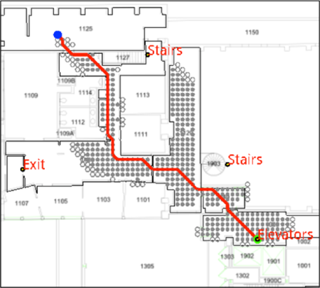 The enhanced route-planning algorithm will allow for planning complete journeys, customized to the traveler’s sensory and mobility constraints and be able to dynamically re-plan in the event of unexpected changes to the environment or due to changes in user intent.
- We develop a graph-based approach to achieve a detailed representation of the environment for efficient routing.
- A graph network of rooms and hallways is formed based on a given floor plan and a path planning algorithm, like D*, is then subsequently applied.
- The graph allows for a compressed representation of large map details and is flexible to allow dynamic changes to be made.
3. Effective interface (How do I communicate that to the user?)
As part of a solution, we will implement a customizable and flexible interface.
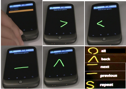 The flexibility is in terms of the input/output modality as well as the verbosity level for specific navigation instructions.
- The input/output modality should be adjustable by the users based on their capabilities and preference.
- We have developed a human-centric interface that gives the user the flexibility to choose the output format of navigation instructions between audio, verbal and tactile (vibration) feedback.
Testing & User Feedback
Testing is a crucial element of any research project, and field testing is an essential component of any system that is to have real-world impact. Testing for this project is executed iteratively with initial user feedback that informs basic design elements of the tools, followed by full field tests once a technology component is completely implemented.
Testing
We implemented a prototype solution on commercial mobile phones (Google Nexus One and Nexus S) and tested in multiple environments.
- Eight subjects participated in the first round of user interface testing, while seven subjects participated in initial indoor positioning tests.
- In a 200m comparison with GPS, the inertial system achieved 8% accuracy compared to 0.5% accuracy given by GPS.
- The implemented system shows a mean error variation of ~5m and closed loop error measurements of ~6m, averaged over the different runs.
User feedback
Participants identified needs for simpler gestures, granularity of instructions, technical issues that may cause crashes or other errors, the need for more audio feedback and fewer, less complicated vibration patterns. Based on this feedback, the NavPal team is working to make changes to the current user interface so that it’s easier to use, clearer, and more accessible for blind and deafblind users. There will be additional rounds of user testing in subsequent months. (Photo caption: Gesture recognition as part of the multi-modal interface)
Policy Implications
Potential Impact
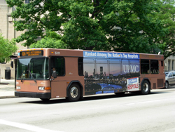 In cities such as Pittsburgh, public transportation is a domain in need of innovative policies and collaborations. Public transportation offers affordable and essential
mobility options in Pittsburgh, particularly for people with disabilities. When used effectively, public transit systems can help bridge the spatial divide between people, jobs, education, healthcare and other necessities. Furthermore, in the context of a steadily aging population and its correlation with disabilities, it is recognized that improved accessibility has important social and economic benefits. (Photo caption: Port Authority Bus | Source: Carnegie Mellon University)
Challenges and Opportunities
Issues such as stop changes, lack of audio information about bus arrivals and bus stops, and uncertainty regarding bus arrival times pose great navigational challenges for people with disabilities who use public transportation. Ideally, this information could be integrated into the NavPal tool and made available to the general public. The NavPal team welcomes communication and collaboration with public transit, community representatives, public officials, and other policy leaders in order to maximize the utility of this technology.


